I’m going to review some highlights however the entire area is simply beautiful.
Just about every turn has something new to discover, a sandy cove, a small
tavern or campground, a fishing hotspot, a deer swimming across the river. You
become immersed in nature and that is exactly why many chose to risk lower unit
and propeller damage to venture into this gorgeous area of the upper Wolf River.
Don’t expect to find any of these local slang terms on any official nautical
map.
To help you get a clear understanding of this area I made a crude map.
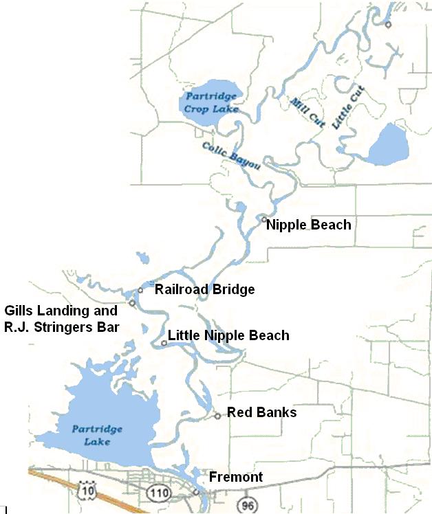
From Partridge Lake you head north upriver.
Red Banks:
The first notable landmark you will pass on your right or starboard side is
called Red Banks http://www.redbanks.net/ (920) 446-2933. They have docks, cabin
rentals, a campground, restaurant and bar.
This is in a no wake zone. I did talk to one boater that lost a propeller right
in the middle of the river in front of Red Banks. This is the only bend I’m
going to say avoid the middle. Hug he outer or inner part of the river keeping
your lower unit up and go slow. We went around the outside going upriver and
inside coming back and did not hit on either side.
A short run upriver past Red Banks you will come to a T in the river. Looking at
the letter T you are coming from the bottom up. This area is another no wake
zone. There is a sign on the north shore that says Pine Grove and an arrow to
the right.
Pine Grove:
We went to the right or starboard towards Pine Grove with our lower unit up as
far as we could. Just past the first no wake buoy into the channel I felt that
unmistakable stern raise and drop as the skeg of the lower unit went over a
submerged log. I turned around and went back out so I am unable to tell you any
additional information on this channel to Pine Grove.
Continuing upstream:
At this T in the river on the south west shore is a small sand beach area if you
are ready for a rest. It’s not very deep and Little Nipple Beach is not much
further. Because of its small size if you do pull up with a friend’s boat you
would likely have the area to yourselves.
Little Nipple Beach:
Heading back upstream you will not get up to plane long and you will come to
another no wake zone. On your right or starboard side just as you start to round
the bend is a small sandy beach area. I’ve talked to a few local boaters that
call this Little Nipple Beach. I’ve not come across that name before at this
site so I don’t know how well that name is known.
This beach is nice but rather small. It’s wide enough for about 4 to 6 boats to
pull ashore. The sandy area from water to vegetation is about 6 to 8 feet deep.
That’s enough for the kids to have some fun or adults to lay out and soak up
some rays.
Little Nipple Beach is not too far past Partridge Lake so this spot is less of a
risk to get to with larger boats or during periods of low rainfall.
Gills Landing/RJ Stringers:
Continuing upriver in a few more minutes and a few more no wake zones you will
come to a public boat landing and small park called Gills Landing on your left,
or port side. The river widens at this point. The building on the north side of
Gills Landing is Stringrs bar.
Just upriver and north of Gils Landing is where the Waupaca River enters the
Wolf River.
Railroad Bridge:
Just north of where the rivers merge and a bit more up the Wolf River you will
see a railroad bridge. Towards the right half of the bridge is an area with a
bit more clearance. Someone took some white spray paint and sprayed by hand
“House boats here” and that is where we cruisers should go. Clearance was about
11 feet from the water to the bridge on the day we went through. Not too bad
unless you have a boat way too big for this area.
Continuing north you pass some beautiful country. Lots of fallen trees making
passage feel constricted but acceptable. I recommend you stick to the middle of
the river as best you can and take the many curves closer to the outside edge
where the water tends to be deeper. I saw depths of 2 feet (from my transducer
mounted at the bottom of the stern of our boat) to 30 feet plus as the river
went around bends.
A few more no wake zones and you will come to a Y in the river. Again you are
coming from the bottom of the Y up. There is a sign marked New London and an
arrow to the right. This is the way you should go if you want to get to Nipple
Beach.
At points you can see no man-made objects at all. Cruising along at planing
speed through this rural geography gives a feeling I simply can’t describe, you
will have to experience it for yourself.
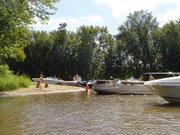
Photo of Nipple Beach: Nipple Beach gets is name due to a local reputation similar to that New Orleans
Mardi Gras tradition. Bring a supply of beads, offer them up to a willing lady
and, well, I’ll let you fill in the rest.
Nipple Beach is about 8 miles upriver from Partridge Lake and going upriver it
will be on your right or starboard side. It’s on the inside bend of an large U
in the river. With the no wake zones and the winding of the river the run from
Partridge Lake takes the better part of an hour. It is one of the most enjoyable
hours you will ever have with your boat.
Nipple Beach is not a public park or campground but a small nice sandy beach
area on the inside riverbank. Its about 100 feet wide, 140 feet if you count the
sandy areas on the side with only a couple of feet of sand before vegetation.
The depth of the beach area varies like a crescent moon but I’d say in the
center its about 50 feet from shore to vegetation.
There is enough room for about a dozen boats plus some nice sandy beach for
small kids to play. The water is shallow enough on the more upriver half of the
bend to toss a ball or other water games.
The river bank changes quite a lot as the beach wraps around the bend. Going
upriver the beginning part of the beach is steep. It’s a fast drop-off to more
then 20 feet of water depth. As you get to the furthest upriver part the river
is very shallow due to a sand bar.
In the picture above you can see our boat a good distance away from shore yet we
are beached on the rivers bottom. On the opposite side of Nipple beach the stern
of the boats are floating and the bows are touching dry sand. Again this is due
to the fast drop off on the downriver side of this curve in the river.
Boaters pull ashore and have fun in the sun during the day, kids making sand
castles, etc. At night its campfires and spirits.
Photo of kids playing on Nipple Beach: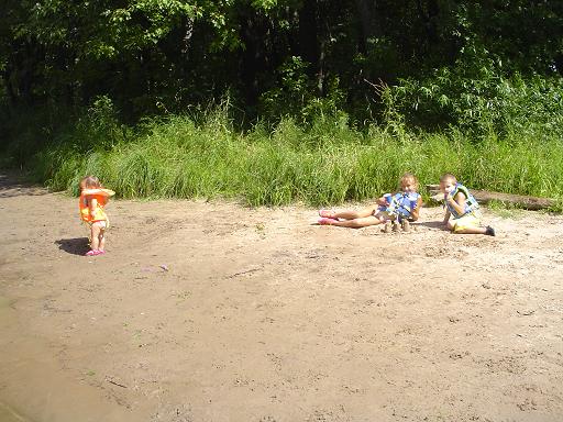 Onshore there is a sign posting “No Camping” displayed on a tree in the middle
of the beach. Just past this and further away from the shore is a “No
trespassing” posting. I did call the Waupaca Sheriffs department for
clarification on the no camping rule. The person on the phone discussed this
with a few others then came back and said they are not sure if the land is
public or private. They were all clear that you could not set up a tent and
spend the night but think its OK to anchor and sleep on a boat pulled up to the
bank.
Due to the sandbar if you are going beyond Nipple Beach follow close to the
outside part as you round this U in the river.
Well, that’s about it. We got a little further then talked to some fishermen in
a small flat bottom boat that told us it gets much shallower from this point on.
Someday I’d still like to get up to Partridge Crop Lake and beyond to New
London. When I do I’ll be sure to provide an update.
Disclaimers – please read
River Depth:
This area is the upper portion of the Wolf River. Being a river the depth varies
greatly. As you go through this area you will see the piers along the way are
built very different then downriver. Most are built to float. A hinged plank
provides a walkway to the shore allowing the pier to move up and down with a
changing river height. Recent rains or lack of rain will greatly affect the
rivers level and the depth between that submerged stump and your propeller.
No Wake zones:
All the no wake zones past Partridge Lake are in effect 24/7. I mention this
because the ones downstream to Fremont are weekend / holiday only. Also, with
sharp blind turns there are a lot of no wake zones.
Drowning:
Many of the rivers edges look very inviting to pull your boat ashore and enjoy.
The grade of the rive bottoms vary and many have sharp drop-offs. I recommend
keeping kids in Life Jackets even when onshore along this area. My apology if
I’m sounding like a worry wart.
Littering:
Much of the land along this portion of the river is private property. This is no
different then the area further downstream except this area has many alluring
sandy banks that are great for pulling ashore. After talking to some locals,
it’s the littering left behind that bothers the land owners the most. What we do
is we bring along some empty plastic grocery bags. Before we leave we pick up
everything we brought plus any other trash we find in the general area.
Boat - SeaRay Sundancer 240
Port - Slip #309, Pioneer Marina, Oshkosh, WI
Lisa

2 comments:
Thank you for this guide! I am really interested in renting a pontoon and exploring the Wolf upriver. Your guide was very helpful and now I am VERY motivated.
I have a few questions regarding boating on the area in general. Would you please email me at steve@visagepoker.com? I'd really appriciate some insight into the area.
Thanks again,
Steve Evans
Milwaukee
This information navigating the Wolf River was very very helpful I am a virgin to the Wolf River and never been on it hopefully this summer will be my time to enjoy Fremont to the North thanks again, Brock
Post a Comment