Showing posts with label Local boating destinations. Show all posts

Wednesday, June 11, 2008

Wisconsin Boating – Wolf River – South Beach

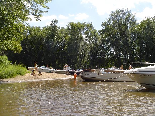
Photo of South Beach on the Wolf River

We have a favorite beach along the Wolf River. Judy Johnson with the Tri-County Powerboat Alliance (link) told me this area is known as “South Beach.”

The river is constantly changing. Just last year this area was small. South Beach has grown and as the water level returns to its normal level it will get even bigger.
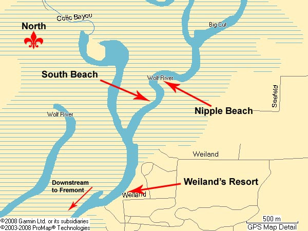
We love the scenic splendor of the undeveloped area along the Wolf River that is north and upriver from Fremont. The area is dotted with a few restaurants and campgrounds and a few homes but there are many areas where you can see no man made objects whatsoever. Nature surrounds you. The experience is breathtakingly beautiful.

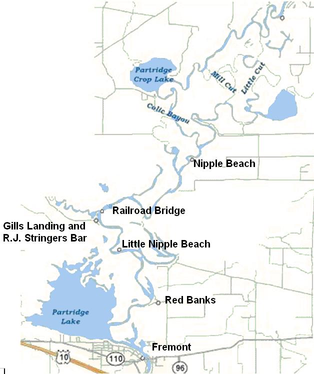
Map courtesy of Paul "Not So Fast!" bekosh


How to get to South Beach from Fremont, Wisconsin

South beach is on the Wolf River about 8 miles upriver from Fremont, WI. South Beach is at the start of the first 'no-wake' zone just upriver from Weiland's Landing. Its about 2 miles before Guth's Resort. It’s across the river and one bend down river from Nipple Beach. It’s right at the start of the ‘no-wake’ zone that also includes Nipple Beach.
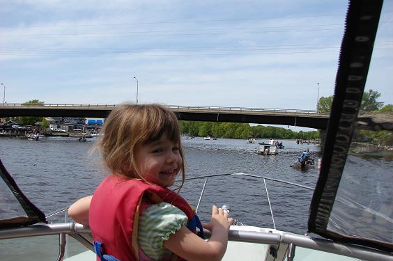

Coming into Fremont on the Wolf River. Bridge Bar to the left. Highway 96 above. Notice all the boat traffic


Going thru Fremont


Going past Red Banks


The first notable landmark past Fremont is called Red Banks http://www.redbanks.net/ (920) 446-2933. They have docks, cabin rentals, a campground, restaurant and bar. As you pass Red Banks the river widens. Stick to closer to the inside of the bend. The area was dredged many years ago and the inside of this bend has much better depth.

Gills Landing:
Continuing upriver in a few more minutes and a few more no wake zones you will come to a public boat landing and small park called Gills Landing on your left, or port side. The river widens at this point.

Just upriver and north of Gills Landing is where the Waupaca River enters the Wolf River.

Railroad Bridge:
Just north of where the rivers merge and a bit more up the Wolf River you will see a railroad bridge. Towards the right half of the bridge is an area with a bit more clearance. Someone took some white spray paint and sprayed by hand “House boats here” and that is where us larger boats should go. Clearance ranges with the height of the river from about 12 feet to 15 feet.

Continuing north you pass some beautiful country. Lots of fallen trees making passage feel constricted but acceptable. I recommend you stick to the middle of the river as best you can and take the many curves closer to the outside edge where the water tends to be deeper.

A few more no wake zones and you will come to a Y in the river. Again you are
coming from the bottom of the Y up. There is a sign marked New London and an
arrow to the right. This is the way you should go if you want to get to South Beach.

These photos were taken on May 24, 2008. The river is very high so I expect the size of South Beach will grow. Also, the sand is still fairly soft, particularly as you get closer to the wooded area. As things dry out this should harden.

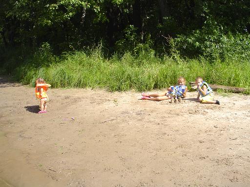
Our kids have enjoyed fishing, swimming, campfires, playing in the inflatable raft, and playing in the sand.


Kids playing on South Beach.


The wind was coming upriver and from West to East and past the boat. I am pulled on the beach with the bow facing west. This is my preferred location so our generator exhaust is carried away from the beach and behind the boat.

There are no facilities or developments at South Beach. It’s primitive. The water becomes a sand beach. The sand beach becomes tall grass. The tall grass becomes woods. Thru the woods I could see water. I think this is Colic Bayou but I did not walk thru the woods that far.


Playing with the inflatable raft


It rained so we made S'mores on the boat


Captain Doug taking a break


Admiral Lisa making sure everyone is having a good time


We have spent three nights at South Beach so far this season and hope to spend many more.


Boating destination “South Beach”
Along the shores of the Wolf River
Weyauwega, Wisconsin
GPS coordinates 44°19.2411'N, -88°50.7964'W

Satellite image clicik
here
This link is to a satellite image. If you would prefer a map, click on “map” in the top right corner. Zoom out as you see fit and print.

Did you find this information helpful? Please let us know by commenting below.

Saturday, April 21, 2007

Slipknot Fremont WI on the Wolf River

Slipknot to re-open April 28, 2007

The bar / resuaurant along the Wolf River in Fremont Wisconsin called the Slipknot will reopen April 28, 2007.

This is a popular spot along the river.
Per Pete, the Slipknot’s owner, he has a new group of investors and will be ready to reopen Saturday, April 28th, 2007

You can call the slipknot at 920-446-2707.

Monday, September 11, 2006

Teds Grandview restaurant in Fremont Wisconsin

This past Saturday we were childless (got a sitter) and took another couple on the boat up the Wolf River to Fremont and had dinner at Ted’s Grandview. http://www.tedsgrandview.com/ We made reservations by calling Ted’s at 920-446-3261.

Earlier this summer we anchored and watched the Ted’s Grandview sponsored fireworks. They were great and I said I was going to make a point to get to this place.

Take the Wolf River to Fremont. After you go under the bridge you go past the Bridge Bar, the Slipknot, hotel Fremont and a few houses. Going upriver Ted’s Grandview will be on your port of left side. If you get past the no-wake zone you went too far. They have docks along the river.

The front of the restaurant is mostly windows. They sit high on the river bank. Due to the location you can see the east half of Partridge lake as well as part of the Wolf River. The view is, well, grand, making the name Ted’s Grandview appropriate.

We had a great time. Wine, appetizers, salad, soup, steaks and the level of service were all excellent. It was a chilly evening so we dined indoors however they do have an outdoor deck.

For a reasonably priced supper club with a relaxing atmosphere, excellent view, friendly service and good food I give Ted’s my two thumbs up.

Saturday, January 07, 2006

Wisconsin Boating – Lake Winnebago – Streich's beach

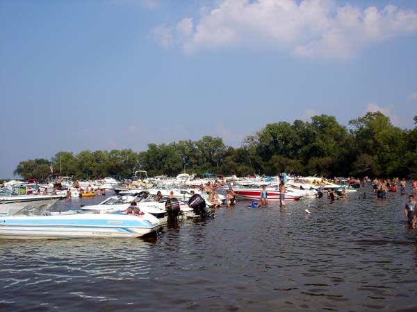
Streich's, is a sand bottomed shallow protected area on Lake Winnebago’s west shoreline about 4 miles south of where the Fox river enterers the lake in Oshkosh. Because of the natural protection from the curvature of the shoreline this area is normally calm even when the lake is rough with whitecaps and strong south west summer winds are blowing.

Photo of Streich’s on Lake Winnebago’s west shoreline.
Photo courtesy of WiParty.com


Our family gets to Streich’s often during the summer weekends and we find it to be a nice family friendly area for anchoring and playing in the water or just standing around enjoying the company of friends’ old and new.

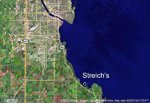
I’ve seen it spelled Streich's, Stretchs, Striech’s, Stretches, Streichs, Strieches or Strietches at various internet forums or websites but it does not really matter how you spell it because this popular Lake Winnebago spot does not appear on any regular map or GPS/Chartplotter chart that I have seen.

I made the below map so if you are in the area West of Oshkosh and would like to give it a try here you go.

Map of Streich’s 4 miles south of Oshkosh along the west shoreline of Lake Winnebago, Wisconsin.


On a clear summer day this spot is easy to find. When you come out of the Fox River in Oshkosh go out about a half mile from shore and head straight south. As you look south you will see a white area along the shoreline. As you get close to this area you will see there is nothing white on the shore, the white is from all the boat hulls gathered in one spot.

Unless you are an early bird, when you arrive there will likely already be hundreds of other boats. I recommend you come in as slow as you can and once the depth gauge reads about three feet cut the engine, trim up the lower unit on your boat as far as you can then jump in the water and walk the boat in the rest of the way. With kids and boat anchor lines in the water this is the safest method on those busy sunny warm summer weekends. If it’s not busy you don’t need to do this.

Most boaters anchor with the bow pointed out away from shore with one anchor off the bow and a second anchor off the stern so the boat does not swing in circles bumping into other boats. Also, if your anchor is in a shallow area please tie a bumper, life preserver or other floating object to the anchor so people do not stub their feet on your anchor as they walk past.

Friends often ‘raft-up’ together, tying one boat to the next. It’s not unusual to see multiple groups of a half dozen or more boats rafted together

It’s a very popular area to drop anchor and socialize, swim, play water volley ball, play catch, cook out, enjoy a beer or mixed drinks with friends or just relax. The closest road that runs parallel to this area is Streich Road however there is no public access from land in this area. There are also no restrooms.

The beach does not go to zero depth so this is not ideal for infant children. There is not a dry sand beach. There are spots of ankle deep water so if you keep a close eye on the little ones they will have a great time. The land along this shoreline is densely wooded and private so the only access is by boat. I’d also recommend keeping kids 12 and under in a life jacket during all boating activities but specifically here since the water depth goes through several shallow and deep oscillations before shore.


Boat - SeaRay Sundancer 240 "Holiday"
Port - Slip #309, Pioneer Marina, Oshkosh, WI
Lisa


Picture of our Sea Ray Sundancer

Wednesday, August 31, 2005

Wisconsin Boating - Lake Butte Des Morts - Sand Pit

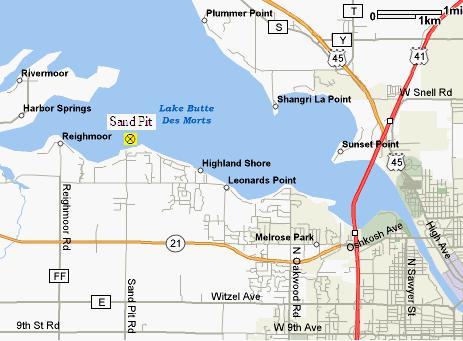
On Lake Butte Des Morts, just west of Oshkosh Wisconsin is a popular shallow sand bottom swimming area called Sand Pit.

We’ve spent some time there lately and find it to be a nice family friendly area for anchoring and swimming or just standing around enjoying the company of friends.

The shoreline is developed with homes and cottages so you can not walk on shore and there is not a dry sand beach or bathroom.

The area is on the southern shore of the lake so most of the time the water is very calm even if the rest of the lake is rough with whitecaps.

The water depths varies from too deep to stand but gets less deep as you get closer to shore. At about twenty feet offshore the depth is about waist high.

I made the below map so if you are in the area West of Oshkosh and would like to give it a try here you go.


Boat - SeaRay Sundancer 240
Port - Slip #309, Pioneer Marina, Oshkosh, WI
Lisa
Picture of our Sea Ray Sundancer

Wisconsin Boating - Wolf River – going upstream from Partridge Lake

Wisconsin Boating - Wolf River – going upstream from Partridge Lake

I’m going to review some highlights however the entire area is simply beautiful.
Just about every turn has something new to discover, a sandy cove, a small
tavern or campground, a fishing hotspot, a deer swimming across the river. You
become immersed in nature and that is exactly why many chose to risk lower unit
and propeller damage to venture into this gorgeous area of the upper Wolf River.
Don’t expect to find any of these local slang terms on any official nautical
map.

To help you get a clear understanding of this area I made a crude map.


From Partridge Lake you head north upriver.

Red Banks:

The first notable landmark you will pass on your right or starboard side is
called Red Banks http://www.redbanks.net/ (920) 446-2933. They have docks, cabin
rentals, a campground, restaurant and bar.

This is in a no wake zone. I did talk to one boater that lost a propeller right
in the middle of the river in front of Red Banks. This is the only bend I’m
going to say avoid the middle. Hug he outer or inner part of the river keeping
your lower unit up and go slow. We went around the outside going upriver and
inside coming back and did not hit on either side.

A short run upriver past Red Banks you will come to a T in the river. Looking at
the letter T you are coming from the bottom up. This area is another no wake
zone. There is a sign on the north shore that says Pine Grove and an arrow to
the right.


Pine Grove:

We went to the right or starboard towards Pine Grove with our lower unit up as
far as we could. Just past the first no wake buoy into the channel I felt that
unmistakable stern raise and drop as the skeg of the lower unit went over a
submerged log. I turned around and went back out so I am unable to tell you any
additional information on this channel to Pine Grove.


Continuing upstream:

At this T in the river on the south west shore is a small sand beach area if you
are ready for a rest. It’s not very deep and Little Nipple Beach is not much
further. Because of its small size if you do pull up with a friend’s boat you
would likely have the area to yourselves.


Little Nipple Beach:

Heading back upstream you will not get up to plane long and you will come to
another no wake zone. On your right or starboard side just as you start to round
the bend is a small sandy beach area. I’ve talked to a few local boaters that
call this Little Nipple Beach. I’ve not come across that name before at this
site so I don’t know how well that name is known.

This beach is nice but rather small. It’s wide enough for about 4 to 6 boats to
pull ashore. The sandy area from water to vegetation is about 6 to 8 feet deep.
That’s enough for the kids to have some fun or adults to lay out and soak up
some rays.

Little Nipple Beach is not too far past Partridge Lake so this spot is less of a
risk to get to with larger boats or during periods of low rainfall.


Gills Landing/RJ Stringers:

Continuing upriver in a few more minutes and a few more no wake zones you will
come to a public boat landing and small park called Gills Landing on your left,
or port side. The river widens at this point. The building on the north side of
Gills Landing is Stringrs bar.

Just upriver and north of Gils Landing is where the Waupaca River enters the
Wolf River.


Railroad Bridge:

Just north of where the rivers merge and a bit more up the Wolf River you will
see a railroad bridge. Towards the right half of the bridge is an area with a
bit more clearance. Someone took some white spray paint and sprayed by hand
“House boats here” and that is where we cruisers should go. Clearance was about
11 feet from the water to the bridge on the day we went through. Not too bad
unless you have a boat way too big for this area.

Continuing north you pass some beautiful country. Lots of fallen trees making
passage feel constricted but acceptable. I recommend you stick to the middle of
the river as best you can and take the many curves closer to the outside edge
where the water tends to be deeper. I saw depths of 2 feet (from my transducer
mounted at the bottom of the stern of our boat) to 30 feet plus as the river
went around bends.

A few more no wake zones and you will come to a Y in the river. Again you are
coming from the bottom of the Y up. There is a sign marked New London and an
arrow to the right. This is the way you should go if you want to get to Nipple
Beach.

At points you can see no man-made objects at all. Cruising along at planing
speed through this rural geography gives a feeling I simply can’t describe, you
will have to experience it for yourself.

Photo of Nipple Beach:

Nipple Beach gets is name due to a local reputation similar to that New Orleans
Mardi Gras tradition. Bring a supply of beads, offer them up to a willing lady
and, well, I’ll let you fill in the rest.

Nipple Beach is about 8 miles upriver from Partridge Lake and going upriver it
will be on your right or starboard side. It’s on the inside bend of an large U
in the river. With the no wake zones and the winding of the river the run from
Partridge Lake takes the better part of an hour. It is one of the most enjoyable
hours you will ever have with your boat.

Nipple Beach is not a public park or campground but a small nice sandy beach
area on the inside riverbank. Its about 100 feet wide, 140 feet if you count the
sandy areas on the side with only a couple of feet of sand before vegetation.
The depth of the beach area varies like a crescent moon but I’d say in the
center its about 50 feet from shore to vegetation.

There is enough room for about a dozen boats plus some nice sandy beach for
small kids to play. The water is shallow enough on the more upriver half of the
bend to toss a ball or other water games.

The river bank changes quite a lot as the beach wraps around the bend. Going
upriver the beginning part of the beach is steep. It’s a fast drop-off to more
then 20 feet of water depth. As you get to the furthest upriver part the river
is very shallow due to a sand bar.

In the picture above you can see our boat a good distance away from shore yet we
are beached on the rivers bottom. On the opposite side of Nipple beach the stern
of the boats are floating and the bows are touching dry sand. Again this is due
to the fast drop off on the downriver side of this curve in the river.

Boaters pull ashore and have fun in the sun during the day, kids making sand
castles, etc. At night its campfires and spirits.

Photo of kids playing on Nipple Beach:

Onshore there is a sign posting “No Camping” displayed on a tree in the middle
of the beach. Just past this and further away from the shore is a “No
trespassing” posting. I did call the Waupaca Sheriffs department for
clarification on the no camping rule. The person on the phone discussed this
with a few others then came back and said they are not sure if the land is
public or private. They were all clear that you could not set up a tent and
spend the night but think its OK to anchor and sleep on a boat pulled up to the
bank.

Due to the sandbar if you are going beyond Nipple Beach follow close to the
outside part as you round this U in the river.

Well, that’s about it. We got a little further then talked to some fishermen in
a small flat bottom boat that told us it gets much shallower from this point on.

Someday I’d still like to get up to Partridge Crop Lake and beyond to New
London. When I do I’ll be sure to provide an update.

Disclaimers – please read

River Depth:

This area is the upper portion of the Wolf River. Being a river the depth varies
greatly. As you go through this area you will see the piers along the way are
built very different then downriver. Most are built to float. A hinged plank
provides a walkway to the shore allowing the pier to move up and down with a
changing river height. Recent rains or lack of rain will greatly affect the
rivers level and the depth between that submerged stump and your propeller.

No Wake zones:

All the no wake zones past Partridge Lake are in effect 24/7. I mention this
because the ones downstream to Fremont are weekend / holiday only. Also, with
sharp blind turns there are a lot of no wake zones.

Drowning:

Many of the rivers edges look very inviting to pull your boat ashore and enjoy.
The grade of the rive bottoms vary and many have sharp drop-offs. I recommend
keeping kids in Life Jackets even when onshore along this area. My apology if
I’m sounding like a worry wart.

Littering:

Much of the land along this portion of the river is private property. This is no
different then the area further downstream except this area has many alluring
sandy banks that are great for pulling ashore. After talking to some locals,
it’s the littering left behind that bothers the land owners the most. What we do
is we bring along some empty plastic grocery bags. Before we leave we pick up
everything we brought plus any other trash we find in the general area.

******************************
Boat - SeaRay Sundancer 240
Port - Slip #309, Pioneer Marina, Oshkosh, WI
Lisa