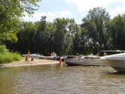
.JPG) Photo of South Beach on the Wolf River
Photo of South Beach on the Wolf RiverThe river is constantly changing. Just last year this area was small. South Beach has grown and as the water level returns to its normal level it will get even bigger.
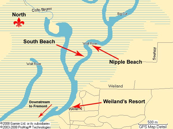 Map courtesy of Paul "Not So Fast!" bekosh
How to get to South Beach from Fremont, Wisconsin
South beach is on the Wolf River about 8 miles upriver from Fremont, WI. South Beach is at the start of the first 'no-wake' zone just upriver from Weiland's Landing. Its about 2 miles before Guth's Resort. It’s across the river and one bend down river from Nipple Beach. It’s right at the start of the ‘no-wake’ zone that also includes Nipple Beach.
Coming into Fremont on the Wolf River. Bridge Bar to the left. Highway 96 above. Notice all the boat traffic
.JPG)
Going thru Fremont
.JPG)
Going past Red Banks
The first notable landmark past Fremont is called Red Banks http://www.redbanks.net/ (920) 446-2933. They have docks, cabin rentals, a campground, restaurant and bar. As you pass Red Banks the river widens. Stick to closer to the inside of the bend. The area was dredged many years ago and the inside of this bend has much better depth.
Gills Landing:
Continuing upriver in a few more minutes and a few more no wake zones you will come to a public boat landing and small park called Gills Landing on your left, or port side. The river widens at this point.
Just upriver and north of Gills Landing is where the Waupaca River enters the Wolf River.
Railroad Bridge:
Just north of where the rivers merge and a bit more up the Wolf River you will see a railroad bridge. Towards the right half of the bridge is an area with a bit more clearance. Someone took some white spray paint and sprayed by hand “House boats here” and that is where us larger boats should go. Clearance ranges with the height of the river from about 12 feet to 15 feet.
Continuing north you pass some beautiful country. Lots of fallen trees making passage feel constricted but acceptable. I recommend you stick to the middle of the river as best you can and take the many curves closer to the outside edge where the water tends to be deeper.
A few more no wake zones and you will come to a Y in the river. Again you are
coming from the bottom of the Y up. There is a sign marked New London and an
arrow to the right. This is the way you should go if you want to get to South Beach.
These photos were taken on May 24, 2008. The river is very high so I expect the size of South Beach will grow. Also, the sand is still fairly soft, particularly as you get closer to the wooded area. As things dry out this should harden.
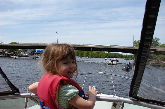
Our kids have enjoyed fishing, swimming, campfires, playing in the inflatable raft, and playing in the sand.
.JPG)
Kids playing on South Beach.
The wind was coming upriver and from West to East and past the boat. I am pulled on the beach with the bow facing west. This is my preferred location so our generator exhaust is carried away from the beach and behind the boat.
There are no facilities or developments at South Beach. It’s primitive. The water becomes a sand beach. The sand beach becomes tall grass. The tall grass becomes woods. Thru the woods I could see water. I think this is Colic Bayou but I did not walk thru the woods that far.
.JPG)
Playing with the inflatable raft
.JPG)
It rained so we made S'mores on the boat
.JPG) Captain Doug taking a break
Captain Doug taking a break .JPG)
Admiral Lisa making sure everyone is having a good time
We have spent three nights at South Beach so far this season and hope to spend many more.
Boating destination “South Beach”
Along the shores of the Wolf River
Weyauwega, Wisconsin
GPS coordinates 44°19.2411'N, -88°50.7964'W
Satellite image clicik here
This link is to a satellite image. If you would prefer a map, click on “map” in the top right corner. Zoom out as you see fit and print.
Did you find this information helpful? Please let us know by commenting below.
6 comments:
I had no idea there was a real name name for the beach south of Nipple Beach. We always called it the Other Nipple or the Left Nipple. There is a bend after Red Banks where you can turn toward Pine Grove Resort. We have beached there and call it the Bellybutton.
heh same here! when I was at Nipple I named the beaches but what I saw and not by it's real name!
made many yacht trips there.. was fantastic
hi...
audio video equipment rentals, audio conferencing equipment rental
http://www.zoomeventsindia.com
Hi,
You have great blog, your posts always prove to be of a high value and quality for readers. Keep it up.
it is Excellent entry,well Sport plays vital role in our lives to keep us active, enthralling and positivist with necessary vitality and force required accomplishing our daily task and routine jobs. You could get more information through this website.
http://www.watersportshut.com/
Pretty nice post. I just stumbled upon your blog and wanted to say that I’ve really enjoyed surfing around your blog posts. In any case I will be subscribing to your rss feed and I hope you write again soon!
Thank you for the good writeup. It in fact was a amusement account it.
Read More: German shepherd husky mix
Post a Comment